Decision time on Leighton's future
Posted on May 1, 2007
Public will get their say on where 37,000 homes are to go.
Property developers with ambitions to build vast housing estates on the northern and eastern edges of Leighton Buzzard could soon see their hopes confirmed.
But on the other hand it is equally possible that Leighton-Linslade might be completely spared from massive further development beyond what is already in the planning system pipeline.
It all depends a lot on what the public tell councillors during a major initial consultation due to start in a month or two's time. If a large majority of people in the town and nearby villages present a strong voice against thousands more homes being added to Leighton's allocation up to 2031, it should have a big influence on the decisions that follow.
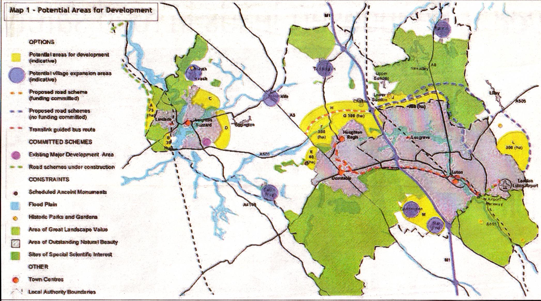
The yellow patches are the maximum potential areas where councillors think new building could be allowed: Click image for full sized version.
A new draft council document indicates that it could still be a realistic aim to place most or even all of the 37,000 new south Bedfordshire homes demanded by the government in Luton and Dunstable.
Ten possible options for building in the district during the coming 24 years have been proposed in a 44-page document called the Core Strategy - Draft Issues and Options Paper.
This includes background information, discussion about transport, jobs, the role of town centres and the need for community facilities.
The Core Strategy is the first fundamental step towards detailed zoning of land for new development by a committee made up of district, county and Luton councillors. This Joint Planning and Transportation Committee includes representation from Milton Keynes and others involved in implementing the Milton Keynes and South Midlands Sub-Regional Strategy.
The committee is working at this stage to decide in outline where the development should go, so detailed planning of estate roads, factories and health centres is well in the future. But although the core strategy only talks about ''five possible alternative approaches to how the development could be distributed'', it is highly important in showing the areas that the committee is interested in considering - and for showing the areas that are not in the frame for rolling back the green belt.
The five options illustrated on maps of south Bedfordshire are headed:
- Development limited to within the bypasses.
- Development not limited to within the bypasses.
- Maximise proximity to town centres and main employment areas.
- Widespread distributional spread.
- Development focussed on Luton.
Each of these is also depicted with minimum and maximum areas of land being allocated for development, depending on the density of housing per acre that is finally decided on.
Densely-packed blocks of flats could obviously provide homes for more people in a smaller area than larger houses with gardens and this would have a direct impact on the amount of green belt countryside that will have to be built on to achieve the government's required total. But social factors also need to be considered and final announcements could be two years away.
Areas that are in the frame to be considered include:
- The land between Derwent Road, and the new Linslade Bypass, bounded by Soulbury Road to the north.
- An arc of land wrapping round the eastern side of Leighton from Cotefield Drive and Heath Road in the north west to the A505 Leighton Bypass in the south. This area is bounded by Shenley Hill Road to the north and stops short of Eggington in the east, but is broken in two by a gap for the Clipstone Brook flood plain. It includes most of the land proposed for future development by a local consortium of land-owners and builders, as exclusively revealed by the LBO last year, if they are allowed to proceed.
- n A 30-hectare strip beside the railway line between Wing Road, on the southern edge of Linslade, and the Leighton Bypass, but not extending up Wing Hill.
- General development in the villages of Heath and Reach, Eaton Bray, Hockliffe, Barton, Toddington, Caddington and Slip End. Five of the ten options do not propose any extra development around Leighton-Linslade, confining it all to extensions of Luton, Dunstable and Houghton Regis.
Objectors who fear that Leighton couldn't cope with thousands more homes and are sceptical about sufficient infrastucture being provided will take heart from this and drive home their case when the Core Strategy questionnaire is made available to the public.
Only one option - "Widespread development, maximum land-take" - suggests allowing development in Heath and Reach, Hockliffe and Eaton Bray. Heath is certainly expected to oppose this idea forcefully, having just reported in its newly-published Parish Plan that 92% of residents voted against any changes whatever being made to the existing green belt.
Stanbridge, Tilsworth, Eggington and Billington are not being mooted for inclusion in the development areas.
You can view and download The Core Strategy Draft Issues and Options Paper on http://agendas.luton.gov.uk/cmiswebpublic/binary.ashx?Document=11439.
Source: Leighton Buzzard Observer, 1 May 2007
Reader Comments
There are currently no comments about this article.